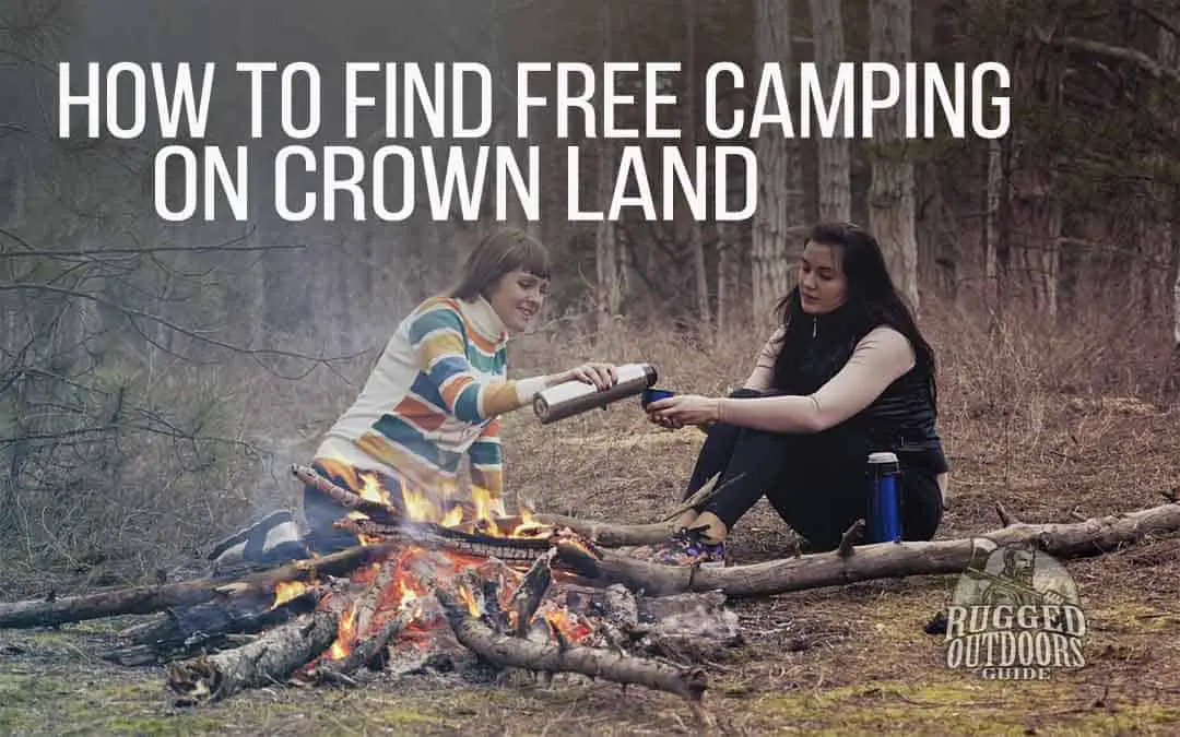
Crown land is a term I’ve heard my whole life growing up in an outdoors-oriented family. But what does it mean, who owns it, how do I know where it is, what can I do on it?
That’s just a start to the thousand additional questions that can be asked about it. Let’s explore a bit more!
Table of Contents
What is Crown Land?
Crown land, is, as the name suggests, owned by a monarch or “king” or head of state. In other words, someone with a right to wear a crown!
Crown land, for practical purposes, means “Public Property” and makes up about 89% of Canada’s landmass. That translates to around nine million square kilometers.
Crown land exists throughout Canada but each province has a different methodology for providing information about crown land use to the public.
I love Ontario’s Crown Land Use Policy Atlas since it is very thorough, though it is a little slow and clumsy to use and navigate.
Who Owns Crown Land?
As the name suggests, Crown land is technically owned by someone with the right to wear a crown in governance over a specified region. In Canada, that means the Queen since we are a part of the British Commonwealth.
In fact, it’s managed by the Federal and/or Provincial governments and any laws are enforced based on Canadian laws.
Can You Live on Crown Land?
Technically, you can live on crown land if you follow the Residential Program guidelines which may provide land to developers. However, for the purposes of this article, we’ll focus on crown land for temporary camping purposes.
What Can You Do on Crown Land?
Crown land can be used for many purposes including building (as long as the rules are followed). Some developers build residences on crown land, while others use crown land for energy projects and still other individuals can rent it from the government for a variety of purposes.
The main interest most people (including myself) have with regards to crown land is the potential for recreational use including (but not limited to) snowmobiling, camping, canoeing, fishing, and hunting.
You can find more information and rules about those recreational activities in Ontario at the Crown Lands Use Policy Atlas found HERE.
Camping on Crown Land
Before we get too far into the details of crown land camping specifics, it’s good to define some basic terms. Often we’ll hear the term “backcountry” camping, which basically refers to an established campsite in a Provincial or State park that is accessed only by hiking through forests or canoeing through lakes or rivers.
It’s a bit rough, but most often backcountry campsites are already cleared away for tents, have landing spots for a canoe, and often have bathroom facilities like a “thunderbox” or backcountry toilet.
The term backcountry can be contrasted with “frontcountry” which would refer to a “softer” or less rugged style of camping like on an electrical-serviced lot at a park with access to showers, swimming pools, parking lots and stores.
However, camping on crown land goes a step beyond even backcountry camping since most often sites are not established and you’ll be trail-blazing just to find a spot to pitch a tent. Crown land camping is best for anyone with at least a few years of wilderness camping experience, or you could run into more problems than it’s worth.
Is it Free to Camp on Crown Land?
Crown land is FREE to camp on if you’re a resident of Canada. You’ll be able to stay at a given spot for up to 21 days before you need to move. Technically it can be as little as a hundred yards away before you set up “camp” again for another 21 days.
If you’re a non-resident of Canada and you’re using crown land in Canada, you’ll need a permit that costs $9.35 per person per day (plus HST). You can get permits via the Ministry of Natural Resources (Ontario) or various government service offices.
While it may be free to use crown land, Jolanta Kowalski (spokesperson for the Ontario Ministry of Natural Resources and Forestry) says that campers should check with regional municipalities and fire departments to see what kind (if any) of fire is allowed on crown land within that municipality.
Going to the Bathroom on Crown Land
It may seem obvious, but there are most likely no facilities for doing your “duty” on crown land. You’ll have to get very basic in your approach like using a tree to lean against or a suspended log to sit on.
It’s best to make a “cat hole” several inches deep when doing a number two and then bury it well and then burn the toilet paper. Personally, I know that TP decomposes in my septic system, so I’m confident it will also decompose in the wild – especially if it is buried along with the “offending matter”.
How to Find Places to Camp on Crown Land in Ontario, Canada
While each province is a bit different, I’m familiar with Ontario’s crown land camping policies because I live in Ontario and spend most of my time camping in the province.
Here’s a step-by-step guide to help you find a free place to camp that is remote and wild, but relatively easy to access with nearby parking;
STEP 1
Determine the general area you’d like to potentially visit for a canoe trip or overnight campout. This may be a very specific area you need to visit because of timing or some other factor, or you may be open to going just about anywhere within a 6-hour drive.
STEP 2
Visit the Ontario Crown Land Use Policy Atlas website. On the home page, click the big (blue) button that says “Use the Crown Land Use Policy Atlas”.

STEP 3
You’ll notice that loading of the next page will be a bit slower than you are used to with regular websites. I’m guessing it’s because there is a lot of information. On the next screen you’ll see a disclaimer. Just “ACCEPT” it to move on to the next screen.

STEP 4
Now you’re ready to navigate the site. To do that, you can click the map anywhere and drag it, but in order to zoom in and out, you’ll have to use the + and – keys near the top left menu (see screenshot).

STEP 5
As you zoom into the area you are considering for your trip, you should notice that your map changes colors. That is a result of numerous overlays that tell you what types of land you are looking at. You can add/delete/change these overlay preferences in the LAYERS tab at the bottom (see screenshot)

STEP 6
Close the “Layers” panel and navigate to the top left where you’ll see a menu bar. On that menu bar, click the tab “MAP LAYERS” and then under that you’ll see another menu bar; click “LEGEND”.
Now you will see in the sidebar, a heading that says “PRIMARY LAND USE AREA”. Under that, you’ll see a list of colors with land use designations. Don’t worry about what they all mean (this is just a basic tutorial to get you to a legal camping spot).
On a piece of paper (or you can keep this page open for reference) write down the only designations you’re looking for (for good, legal camping). Those are:
- Enhanced Management Area
- General Use Area
- Recommended Provincial Park
There are other areas where you can camp, but these 3 areas (especially the first 2) make up the vast majority of land in Ontario that is useable for camping.
In the next steps, you’ll see how to find out what land has any of those designations, and you ARE LOOKING FOR land with those designations.

STEP 6
Now click on the menu tab item “FIND INFORMATION”. You will then see on the very far left, an icon that says “GET LAND USE INFORMATION”. You will select that icon.

STEP 7
In the side panel (see screenshot) you will see a button with a blue circle beside a garbage can. Select the blue circle button. This selection allows you to click anywhere on the map to find out the land designation of that piece of property.
Again, looking at the side panel, you’ll see information displayed about the piece of property you selected. In my example, you’ll see that it says “ENHANCED MANAGEMENT AREA”.
You’ll remember from earlier, that you WANT TO FIND either “Enhanced Management Area” or “General Use Area”. If you do, then you are allowed to camp for FREE in this area just about anywhere that is suitable for a tent or hammock.

CONGRATULATIONS – YOU OFFICIALLY KNOW HOW TO FIND FREE CAMPING (IN ONTARIO ANYWAY)!
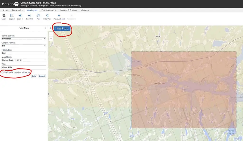
STEP 8
Print Your Map – click on the blue “I want to…” tab at the top of the map. In the side panel you can choose your scale (will depend on the length of your trip and the size of paper in your printer).
Be sure to UNCHECK the “Lock print preview with map” option in the side bar so you can move the print area wherever you need to on the map.
STEP 9 (Unfortunately)!
WHAT? “More steps,” you ask!? Well, this last step is a big one, and I won’t outline it in detail. However, I will give you some direction. This step involves further research to see if your chosen area is suitable as a camping area for you, your family or a group of 15 paddlers!
The first step would be to see your chosen property has any access roads close by. In my example (I’m looking to camp on Dollars Lake in North Central Ontario), I’ve identified a road that appears to lead to the edge of the lake (see screenshot).

Once I see a road that leads near or to the place I’m considering, I would then do a number of other things like:
- Google anything that might help like “Access Road to Dollars Lake Ontario” to find more details about the road and where I might launch my canoe.
- Use Google Maps or Google Earth to zoom into areas where the road stops at or crosses a lake. You may find parking lots, boat launches, etc.
- Search online for “campsites” or “tent campsites on Dollars Lake”, etc. to see if any further information can be found on campsite locations.
- You may want to start your search using a resource like myccr.com for available canoe routes and then use the Crown Land Atlas in conjunction with route details and descriptions.

Other FREE Camping Options in Ontario
Crown land is not the only free option for camping in Ontario or other provinces. Another great option is to research “NON-OPERATING PROVINCIAL PARKS ONTARIO“.
You’ll find areas like Noganosh Provincial Park just South of North Bay and Lake Nipissing. You’ll find links to maps and resources outlining the park itself, camp spots throughout the lake, etc.
Non-operating parks are free to use and often have established campsites though amenities vary greatly. There are websites you can search for that review non-operating parks and their suitability for a whole variety of factors.
Here are some basic sites that I use for each trip:
- Canadian Canoe Routes (my ccr)
- Ontario Parks Locator (for non-operating parks)
- Ontario Crown Land Use Policy Atlas
- My Topo (maps for U.S. locations)
- Yellow Maps (maps for Canadian locations)
Important Safety Note !!!
If you’re camping on crown land or non-operating Provincial parks, there’s about a 0% chance you’ll have a cell phone connection. You’ll also be (in most cases) quite a distance from anyone who can help you if you run into an emergency situation like a broken bone, illness, external injuries/bleeding, or an irreparably broken canoe.
In such a situation, your only hope is to have something that uses satellite communication to contact authorities.
Many avid canoeists use systems like the ZOLEO communicator or the SPOT unit. They are great units but along with the one we like best – THE GARMIN IN REACH, they require monthly service fees.
Since I can go without 2-way communication and I’m very “frugal”, I have decided to go with a unit that requires NO on-going fees, but only a one-time purchase fee. It’s not as versatile as the others I mentioned earlier because it is not a TWO-WAY communicator.
It’s only to be used in a dire emergency, and it’s ONE-WAY only – straight to the rescue team that will come get you! The unit I use is called the ACR Emergency Locator Beacon.
This beacon is probably the best value for any unit of its kind, and perhaps the best money spent on something you’ll hopefully never use!
 ACR 2922")
Here’s the Emergency Locator Beacon I use on all my trips. It costs only a 1-time purchase price and the battery lasts 5 years or more.
Key Takeaways
Finding free camping is possible in most regions of North America if you know how to research and ask questions. I’ve attempted to give you a shortcut in your research if you’re looking to camp for free in Ontario because Ontario is one of the largest jurisdictions on the planet and is the destination of countless visitors (campers, canoeists/kayakers, hikers and eco-tourists) from all over the world each year.
I trust you’ll be able to take some of this information and get it working for you so you can get out there and enjoy God’s creation while it lasts and you’re able to explore it!